
Peoria Neighbors Block Sources
No single Peoria record names everyone around an address. The official sources answer narrower questions. Maricopa County GIS outlines lots and links to tax owners. Peoria GIS names mapped associations and their management contacts. A lawful voter file can show registrants but omits protected people and everyone who is not registered. Older householders directories capture a past edition year rather than the present block.
| Source | What it shows about a block | Access |
|---|---|---|
| Maricopa Parcel Viewer | Parcel boundaries, tax-owner links, subdivisions, and ZIP | Free map; 1,000-result cap |
| Peoria HOA GIS | Community polygons, association names, and management contacts | Free public GIS; no member roster |
| Maricopa voter list | Authorized public fields for registrants in a district | Written request and statutory limits |
| Peoria permits | Work at an address and project actors | Public search or city request |
| Historic householders | Named occupants and nearby addresses in an edition year | Digitized or archival directories |
The tax owner may live elsewhere. A permit applicant may be a contractor. Voter data covers registrants, not all adults or citizens. These limits are not minor details. They define what a neighbor lookup can honestly establish.
Map Peoria Neighbors by Parcel
The Maricopa County Assessor Parcel Viewer supports a close block search without turning the task into a whole-street survey. Begin with address autocomplete, click the underlying parcel, and open Property Information. The situs address is the parcel's physical tax location. Its mailing address is where owner correspondence goes, so the two fields may differ.
- Search the known Peoria address and zoom to its parcel.
- Enable Parcels as a selectable layer.
- Click the parcels next door, using the arrows to review several selected features.
- Open each parcel's Property Information link and record the APN, owner, situs, and subdivision.
- Compare owner mailing and situs fields without treating a match as proof of occupancy.
An APN is the assessor's parcel number. It is more stable than a display label and connects the map to the tax card. For research along the full road, the Peoria street directory carries the broader address chain.
Note: The adjacent-parcel method keeps a Peoria neighbor search focused on the immediate block instead of an unrelated postal area.
Buffer a Peoria Block Lookup
Adjacent clicks work for the lots next door. For a radius, Parcel Viewer can draw a line, extent, circle, or polygon and then buffer the result. Search actions can create a new result set, add features, or remove them. A multi-part selection can combine several shapes.
Populate Results first. Switch to Buffer Something, enter the distance and unit, then apply the buffer. Choose either Entirely within the Buffer or Within or touching the Buffer. That distinction matters at the edge. The first keeps parcels wholly inside; the second includes parcels crossed by the boundary.
Results can be reviewed in an attribute table or exported as CSV or GeoJSON. GeoJSON is structured map data. An export makes comparison easier, but it remains a parcel-owner dataset, not a roll of Peoria neighbors who currently occupy each home.
Each selected feature can link to Property Information, a parcel sketch, aerial imagery, Street View, or a tax summary. Recorded subdivision plats are available where the parcel carries an MCR link. These views help confirm that the shape belongs to the intended block before names are compared. Clear the result set between unrelated searches so one Peoria area is not mixed with another.
Peoria Neighborhood GIS Contacts
Peoria adds a civic layer that the county parcel map does not. The official HOA and neighborhood GIS service publishes community polygons, management-company fields, and manager contact information. Its legend includes 293 HOA mailer properties along with non-HOA, nonresidential, and vacant-land categories.
The official Peoria HOA and neighborhood GIS service and its fields are shown below.
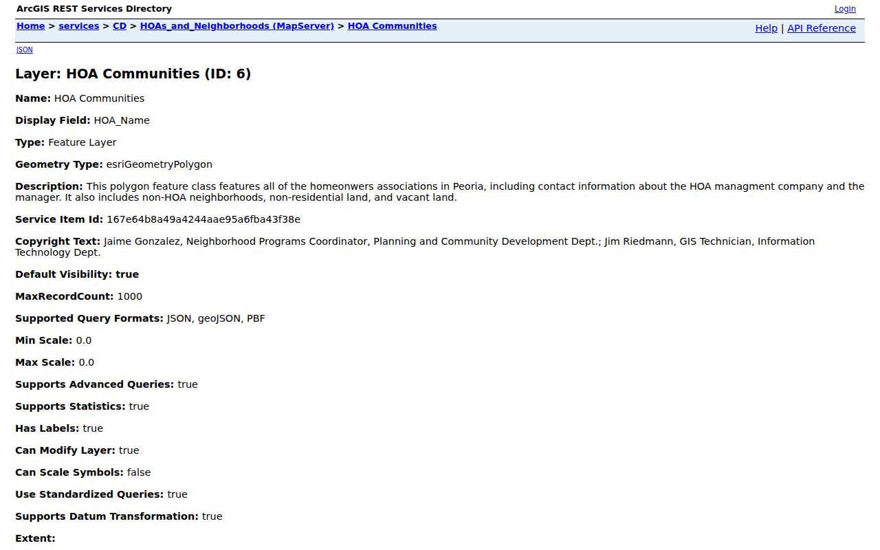
The layer helps distinguish a mapped association from a broader named neighborhood. It does not expose residents or an HOA membership directory.
| Mapped Peoria area | Useful GIS context |
|---|---|
| Westbrook Village and Ventana Lakes | Association polygons and management-contact fields |
| Vistancia, Trilogy, and Blackstone | Master area with communities and subassociations |
| WestWing Mountain and Sonoran Mountain Ranch | North Peoria community geography |
| Desert Harbor, Camino A Lago, and Terramar | Named neighborhood or HOA layer entries |
| Sun Air and Deer Village | Local association context, not a resident roster |
Note: A mapped Peoria association supplies community context and management contact fields, not a list of the people who belong to it.
Contact Peoria Community Associations
Use the mapped management contact to ask about association business, public meetings, or the proper way for an eligible member to seek community information. Do not infer membership from an owner's name. Ownership, residency, and association status are separate facts.
Peoria HOA Map
Open the city neighborhood map to identify the polygon attached to an address.
GIS Service Fields
Review the official service for association, management company, and manager-contact attributes.
County Parcel Context
Match the HOA polygon against the APN and subdivision in Parcel Viewer before contacting a group.
Peoria's mapped inventory includes Fletcher Farms, Pleasant Valley HOA, Peoria Legacy, Peoria New River Ranch, and many subassociations. A parcel outside a mapped HOA may still lie in a named non-HOA community. The layer makes that difference visible.
Association management can explain its own public process or direct a member to the right contact. The city layer can also mark vacant and nonresidential land, which prevents a blank association result from being read as a missing household. A civic polygon describes administration and place. It does not establish who slept at an address on any date.
Peoria Neighbor Voter Records
The Arizona Voter Information Portal is a self-check tool. It uses identifying inputs and is not a public name-only neighbor browser. A person can verify their own registration status, districts, notices, ballot-by-mail status, and participation history. Participation history shows elections, never the choices marked on a secret ballot.
Block-oriented research uses the Maricopa voter-record request channel, not automated queries against self-lookup. The official voter-data request form asks for a defined legislative, congressional, supervisorial, precinct, or countywide district and a status selection. A requested list can include permitted name, registration, address, party, phone, status, and election-participation fields.
The governing A.R.S. §16-168 places use and reproduction restrictions on voter information. Protected voters are omitted under A.R.S. §16-153. The successful research capture below shows the Arizona law governing access.
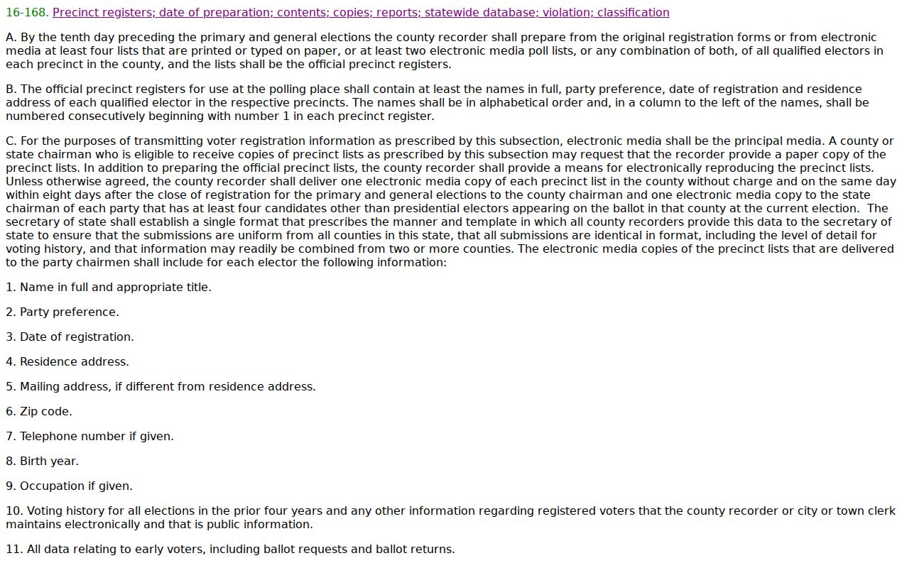
The statute explains why lawful file access differs from an unrestricted block directory. Even an authorized extract confirms registration at an address only as of its data date.
Historic Peoria Neighbors by Address
Old Town blocks leave a different trail from northern master-planned areas. The 1949-50 Salisbury householders section and the 1962 Cole criss-cross directory organize evidence by address, allowing a researcher to see named occupants near one another in an edition year. A criss-cross directory is arranged by street or phone rather than only by surname.
The record does not carry forward to today. Directory editions have gaps, optical character recognition can misread names, and publication often depended on available listings. Pair the page image with a deed, assessor record, census household through 1950, or obituary before treating two same-name entries as one person.
This method can help family-history work and classmate reunions. In Vistancia, Blackstone, WestWing, and other modern north Peoria communities, plats, current assessor records, permits, and HOA GIS are usually more relevant than mid-century directories.
Compare Peoria Block Sources
Commercial neighbor tools blend tax records, marketing files, and directories. They can merge people with the same name or retain an old address. Official records are narrower but disclose who created the record and what it actually represents.
| Question | Official source | Commercial compilation |
|---|---|---|
| Who owns the parcel? | Assessor tax roll tied to APN | May copy an old owner field |
| What is the community? | Peoria GIS polygon and management data | May use a broad neighborhood label |
| Who is registered there? | Controlled county voter request with protected records omitted | Coverage and source date may be unclear |
| Who lives there now? | No single official roll proves all occupants | Compiled result still cannot prove occupancy |
Use a compilation, if encountered, only as a lead. Verify a parcel with the assessor and a community with Peoria GIS. Never turn a tax-owner result into a claim about every person at the address.
Note: A current mailing match can support a clue, but it does not convert a parcel card into a household roster.
Privacy for Peoria Neighbors
Private occupants, children, utility customers, delivery data, and Address Confidentiality Program participants remain outside this block method. Arizona's ACP gives qualified survivors a substitute address and mail forwarding. Protected registration prevents the real address from appearing on public voter lists.
Public records access does not permit threatening contact, surveillance, impersonation, or disclosure of protected locations. Arizona harassment and stalking laws include A.R.S. §§13-2921 and 13-2923. When a source conflicts with direct knowledge, correct the record with its official custodian rather than broadcasting a disputed address.
Lawful use. Research Peoria neighbors for civic curiosity, reconnection, and personal safety, never to watch, harass, intimidate, or expose someone.